In a rare and visceral backlash against one of the company’s biggest initiatives in years, Apple fans are irate over false, or deceptive, information in the new iOS 6 Maps app. After touting an all-new experience, with 3D “Flyover” abilities and free turn-by-turn navigation, iOS 6’s Maps was supposed to, along with eschewing YouTube, remove most traces of Google from the mobile operating system.
But as people downloaded iOS 6 and tested out the new Maps offering, it became quickly apparent that the old Google Maps, despite its lack of vector-based graphics and turn-by-turn, was far more accurate and complete than Apple’s nascent data points. In fact, there are so many errors in Apple’s Maps data that a Tumblr has been created to showcase all of the discrepancies.
In a statement made to AllThingsD, an Apple spokesperson said: “Customers around the world are upgrading to iOS 6 with over 200 new features including Apple Maps, our first map service … We are excited to offer this service with innovative new features like Flyover, turn by turn navigation, and Siri integration. We launched this new map service knowing it is a major initiative and that we are just getting started with it. Maps is a cloud-based solution and the more people use it, the better it will get. We appreciate all of the customer feedback and are working hard to make the customer experience even better.”
Whether this means that things will get better quickly, or take months to flesh out its many error-filled sights remains to be seen. But what was considered a small compromise during the beta (likely because many beta testers were using iOS 6 in major cities, which are more accurate than rural areas) has turned into a full-blown PR nightmare for Apple.
It might be a bit unfair to be hurling such criticism at Apple this early in the game; both Google and Nokia have multiple years of historical data, and while TomTom is providing much of the underlying data structure for these maps, the company denies that it is at fault. “We supply maps and related content to the majority of handheld players, including RIM, HTC, Samsung, AOL (MapQuest Mobile), Apple and, yes, Google (for the areas where they don’t make their own maps). When people use a map, their experience is determined by two things. Firstly, the underlying content, notably the maps. This is what TomTom is currently supplying the mobile industry with and it is what gives their maps the best foundation. Secondly, user experience is determined by adding additional features to the map application, such as visual imagery. This is typically defined and created by the handset manufacturers and third-party software providers on the basis of their own vision and needs.”
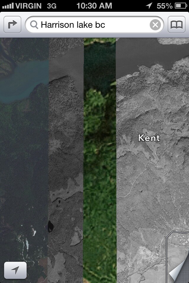
Of course, the fact of the matter is that nobody wants to take responsibility for an unfinished product. While I have yet to experience incorrect directions or stark omissions in Toronto, it seems that large Canadian cities are among the most accurate and complete at this point. We’ve shown you the difference between Apple’s 3D and non-3D satellite imagery, and the technology is just astounding. It doesn’t excuse the basic omissions and misdirections people are receiving, but it points to a brighter future ahead.
Via: AllThingsD
MobileSyrup may earn a commission from purchases made via our links, which helps fund the journalism we provide free on our website. These links do not influence our editorial content. Support us here.