Google is reimagining how it can help people navigate, all powered by AI, while also helping developers make innovative products for their customers.
According to Google, it makes 50 million updates to Google Maps each day, and Maps has over 300 million contributors, 250 million businesses with helpful information, ratings, reviews, photos and more, and 10,000 local governments, transit agencies, and organizations that partner with it.
Further, the company said that Maps provide 20 billion km of directions every single day, and that 90,000km of bike lanes and bikeable roads were added to maps last year alone.
Maps’ fuel efficiency routing feature, since launch, has also prevented 2.4 million metric tons of C02e emissions, which is roughly equal to taking 500,000 fuel-based cars off the road for an entire year.
Talking about the future of Google Maps, Google said that it aims to:
- Make the map more visual and immersive
- Help people make more sustainable choices, and
- Extend its technology to developers and cities.
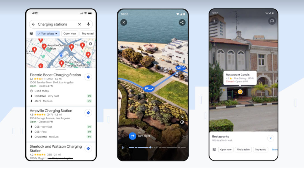
The company announced Immersive View for Routes earlier this year. The feature essentially allows you to preview every step of your journey, whether you’re driving, walking, or cycling. According to the company, the feature uses computer vision and AI to fuse billions of Street View and aerial images together to create a rich, digital model of the world. With the feature, users can access a multidimensional view of their route, complete with detailed turn-by-turn directions and a time slider that can be used to simulate what weather and traffic will be like at the time you plan to travel.
Google says that immersive View for routes is starting to roll out in Amsterdam, Barcelona, Dublin, Florence, Las Vegas, London, Los Angeles, Miami, New York, Paris, San Francisco, San Jose, Seattle, Tokyo and Venice on Android and iOS. “Locations in Canada, coming soon!”
Search with Live View, now known as Lens in Maps, first debuted four years ago. Since then, the feature has received several quality updates. The feature uses AI and AR (Augmented Reality) to allow users to point their phones at their surroundings and gain information about nearby ATMs, transit stations, restaurants, coffee shops, etc.
The feature is now making its way to 50 new cities, including Montréal, Toronto, Vancouver, Austin, Las Vegas, Rome, São Paulo and Taipei.
Additionally, Maps will now feature updated colours and realistic building representations to better aid driver orientation. Highway navigation will also become easier with enhanced lane details, allowing you to be prepared for that tricky exit you always miss. Detailed maps will roll out in the coming months in 12 countries, including Canada, the U.S., France and Germany.
For EV drivers, Google Maps will roll out a feature that will show detailed EV charging station information for Android and iOS users, including information like whether the nearest charger to you is compatible with your vehicles, and whether it is a fast, medium, or slow charger. “And since Canada’s public charger installations grew 30 per cent since the start of 2022, you can now locate new ones on your way and see when a charger was last used to help you avoid wasting time heading to a broken charger,” says Google.
The feature is rolling out in Canada this week for iOS and Android.
The new updates, and expansion of available features to more countries promise to make travelling, navigating planning trips, and discovering new places easier for users globally.
Read more about the updates here.
Image credit: Google
MobileSyrup may earn a commission from purchases made via our links, which helps fund the journalism we provide free on our website. These links do not influence our editorial content. Support us here.
